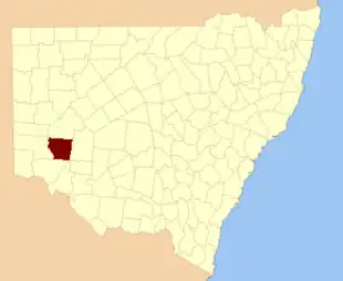
| Parish | LGA | Coordinates |
| Astolat | Central Darling Shire | 32°50′25″S 142°45′54″E / 32.84028°S 142.76500°E / -32.84028; 142.76500 (Astolat) |
| Barrara | Wentworth Shire | 33°06′55″S 142°21′41″E / 33.11528°S 142.36139°E / -33.11528; 142.36139 (Barrara) |
| Barritt | Wentworth Shire | 32°57′37″S 142°27′15″E / 32.96028°S 142.45417°E / -32.96028; 142.45417 (Barritt) |
| Beela | Wentworth Shire | 33°19′27″S 143°14′44″E / 33.32417°S 143.24556°E / -33.32417; 143.24556 (Beela) |
| Bell | Wentworth Shire | 33°28′58″S 142°42′15″E / 33.48278°S 142.70417°E / -33.48278; 142.70417 (Bell) |
| Bertram | Wentworth Shire | 33°25′44″S 143°09′07″E / 33.42889°S 143.15194°E / -33.42889; 143.15194 (Bertram) |
| Bimpia | Wentworth Shire | 32°56′49″S 142°59′21″E / 32.94694°S 142.98917°E / -32.94694; 142.98917 (Bimpia) |
| Blenalben | Wentworth Shire | 32°55′41″S 143°16′39″E / 32.92806°S 143.27750°E / -32.92806; 143.27750 (Blenalben) |
| Burke | Wentworth Shire | 33°05′17″S 142°44′22″E / 33.08806°S 142.73944°E / -33.08806; 142.73944 (Burke) |
| Camelot | Wentworth Shire | 33°00′35″S 143°05′11″E / 33.00972°S 143.08639°E / -33.00972; 143.08639 (Camelot) |
| Coonong | Wentworth Shire | 33°00′12″S 143°10′53″E / 33.00333°S 143.18139°E / -33.00333; 143.18139 (Coonong) |
| Cooyarunda | Wentworth Shire | 32°54′47″S 142°51′50″E / 32.91306°S 142.86389°E / -32.91306; 142.86389 (Cooyarunda) |
| Darchy | Wentworth Shire | 33°20′54″S 142°36′45″E / 33.34833°S 142.61250°E / -33.34833; 142.61250 (Darchy) |
| Enid | Wentworth Shire | 33°03′42″S 142°58′23″E / 33.06167°S 142.97306°E / -33.06167; 142.97306 (Enid) |
| Euchla | Wentworth Shire | 33°20′44″S 142°43′33″E / 33.34556°S 142.72583°E / -33.34556; 142.72583 (Euchla) |
| Garnpung | Wentworth Shire | 33°32′15″S 143°08′07″E / 33.53750°S 143.13528°E / -33.53750; 143.13528 (Garnpung) |
| Glenstal | Wentworth Shire | 33°03′52″S 142°22′56″E / 33.06444°S 142.38222°E / -33.06444; 142.38222 (Glenstal) |
| Gray | Wentworth Shire | 33°07′24″S 143°04′14″E / 33.12333°S 143.07056°E / -33.12333; 143.07056 (Gray) |
| Gunpanoola | Wentworth Shire | 32°53′06″S 142°44′47″E / 32.88500°S 142.74639°E / -32.88500; 142.74639 (Gunpanoola) |
| Harley | Wentworth Shire | 33°15′25″S 142°37′09″E / 33.25694°S 142.61917°E / -33.25694; 142.61917 (Harley) |
| Howitt | Wentworth Shire | 33°12′07″S 142°43′40″E / 33.20194°S 142.72778°E / -33.20194; 142.72778 (Howitt) |
| Kandra | Wentworth Shire | 33°11′43″S 143°17′34″E / 33.19528°S 143.29278°E / -33.19528; 143.29278 (Kandra) |
| Karpakora | Wentworth Shire | 32°53′33″S 143°06′10″E / 32.89250°S 143.10278°E / -32.89250; 143.10278 (Karpakora) |
| King | Wentworth Shire | 33°10′27″S 142°57′25″E / 33.17417°S 142.95694°E / -33.17417; 142.95694 (King) |
| Mapenny | Wentworth Shire | 33°17′27″S 142°56′26″E / 33.29083°S 142.94056°E / -33.29083; 142.94056 (Mapenny) |
| Midgehope | Wentworth Shire | 33°00′59″S 143°21′13″E / 33.01639°S 143.35361°E / -33.01639; 143.35361 (Midgehope) |
| Mitchell | Wentworth Shire | 33°27′07″S 142°55′02″E / 33.45194°S 142.91722°E / -33.45194; 142.91722 (Mitchell) |
| Mooloolerie | Wentworth Shire | 33°01′58″S 142°44′48″E / 33.03278°S 142.74667°E / -33.03278; 142.74667 (Mooloolerie) |
| Moorara | Wentworth Shire | 33°10′29″S 142°21′17″E / 33.17472°S 142.35472°E / -33.17472; 142.35472 (Moorara) |
| Morthong | Wentworth Shire | 33°11′48″S 143°09′46″E / 33.19667°S 143.16278°E / -33.19667; 143.16278 (Morthong) |
| Mueller | Wentworth Shire | 33°24′13″S 142°55′28″E / 33.40361°S 142.92444°E / -33.40361; 142.92444 (Mueller) |
| Mungo | Wentworth Shire | 33°23′01″S 142°49′15″E / 33.38361°S 142.82083°E / -33.38361; 142.82083 (Mungo) |
| Mythe | Wentworth Shire | 33°08′35″S 142°28′43″E / 33.14306°S 142.47861°E / -33.14306; 142.47861 (Mythe) |
| Nambucurra | Wentworth Shire | 33°14′14″S 143°03′14″E / 33.23722°S 143.05389°E / -33.23722; 143.05389 (Nambucurra) |
| Nanda | Wentworth Shire | 33°03′40″S 142°36′26″E / 33.06111°S 142.60722°E / -33.06111; 142.60722 (Nanda) |
| Nania | Wentworth Shire | 33°21′13″S 143°02′12″E / 33.35361°S 143.03667°E / -33.35361; 143.03667 (Nania) |
| Nelia | Wentworth Shire | 33°11′08″S 142°32′35″E / 33.18556°S 142.54306°E / -33.18556; 142.54306 (Nelia) |
| Nuccalo | Wentworth Shire | 32°49′15″S 143°12′31″E / 32.82083°S 143.20861°E / -32.82083; 143.20861 (Nuccalo) |
| Pan Ban | Wentworth Shire | 33°16′52″S 143°08′58″E / 33.28111°S 143.14944°E / -33.28111; 143.14944 (Pan Ban) |
| Peppora | Wentworth Shire | 32°52′12″S 142°36′46″E / 32.87000°S 142.61278°E / -32.87000; 142.61278 (Peppora) |
| Perry | Wentworth Shire | 33°27′49″S 143°01′13″E / 33.46361°S 143.02028°E / -33.46361; 143.02028 (Perry) |
| Pines | Wentworth Shire | 32°56′33″S 142°36′58″E / 32.94250°S 142.61611°E / -32.94250; 142.61611 (Pines) |
| Pombra | Wentworth Shire | 33°08′34″S 142°36′00″E / 33.14278°S 142.60000°E / -33.14278; 142.60000 (Pombra) |
| Pooncaira | Wentworth Shire | 33°28′06″S 142°35′39″E / 33.46833°S 142.59417°E / -33.46833; 142.59417 (Pooncaira) |
| Porcupine | Central Darling Shire | 32°46′33″S 142°54′17″E / 32.77583°S 142.90472°E / -32.77583; 142.90472 (Porcupine) |
| Prunella | Central Darling Shire | 32°44′41″S 142°35′31″E / 32.74472°S 142.59194°E / -32.74472; 142.59194 (Prunella) |
| Tarcoola | Wentworth Shire | 33°27′55″S 142°48′19″E / 33.46528°S 142.80528°E / -33.46528; 142.80528 (Tarcoola) |
| Tarmoola | Wentworth Shire | 33°03′07″S 142°51′56″E / 33.05194°S 142.86556°E / -33.05194; 142.86556 (Tarmoola) |
| Tartna | Central Darling Shire | 32°53′32″S 142°26′10″E / 32.89222°S 142.43611°E / -32.89222; 142.43611 (Tartna) |
| Timpunga | Wentworth Shire | 33°17′02″S 142°29′15″E / 33.28389°S 142.48750°E / -33.28389; 142.48750 (Timpunga) |
| Tolarno | Central Darling Shire | |
| Tuckinya | Wentworth Shire | 32°46′45″S 143°04′00″E / 32.77917°S 143.06667°E / -32.77917; 143.06667 (Tuckinya) |
| Wanteboolka | Wentworth Shire | 33°05′01″S 143°15′15″E / 33.08361°S 143.25417°E / -33.08361; 143.25417 (Wanteboolka) |
| Welsh | Wentworth Shire | 33°12′49″S 142°50′30″E / 33.21361°S 142.84167°E / -33.21361; 142.84167 (Welsh) |
| Wentworth | Wentworth Shire | 33°00′28″S 142°29′32″E / 33.00778°S 142.49222°E / -33.00778; 142.49222 (Wentworth) |
| Wills | Wentworth Shire | 33°06′03″S 142°51′30″E / 33.10083°S 142.85833°E / -33.10083; 142.85833 (Wills) |
| Wreford | Wentworth Shire | 33°12′37″S 142°26′18″E / 33.21028°S 142.43833°E / -33.21028; 142.43833 (Wreford) |
| Yenda | Central Darling Shire | |