Naval Facility Cape Hatteras
35°15′29.4″N 75°31′19.4″W / 35.258167°N 75.522056°W

Naval Facility Cape Hatteras (NAVFAC Cape Hatteras) was a Sound Surveillance System (SOSUS) shore terminal, during the Cold and located on Cape Hatteras near Buxton, North Carolina and adjacent to the old location of the Cape Hatteras lighthouse.[1][2] NAVFAC Cape Hatteras, eighth of the initial nine Atlantic systems to be activated, was in commission 11 January 1956 to 30 June 1982.[1][2]
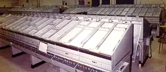
The system and shore facilities, in which output of the array at sea was processed and displayed by means of the Low Frequency Analyzer and Recorder (LOFAR), were officially described as being engaged in oceanographic research.[3] The actual function of undersea surveillance was declassified in 1991 long after the facility had closed.[1] In military construction hearings during 1964 before the Senate Committee on Armed Services the request for funding of recreational and other support buildings for the Naval Facility the Navy noted it was part of a program supporting continental air and missile defense forces without mention of its role in tracking Soviet missile submarines.[4] On 26 June 1962 NAVFAC Cape Hatteras made the first SOSUS detection of a Soviet diesel submarine.[1][5]
Geography
Naval Facility Cape Hatteras was locatd on Cape Hatteras near Buxton, about 240-miles southeast from Raleigh; when the facility initially opened, it was only accessibly via ferry from the Oregon Inlet. The ferry discontinued service at night during winter months and there were frequent interruptions due to weather and sea conditions. By 1963 there were 122 Navy personnel and 180 dependents resident at the facility.[4][6]
History
The Sound Surveillance System (SOSUS) was one of the nine initial systems installed during the Cold War from 1956 to June 1982.[7]
United States Coast Guard "Group Cape Hatteras" occupied some of the facility buildings from 1981 to 2005. The Coast Guard demolished remaining buildings and as of 2013, the site was desirable as beach access and possible construction of changing and rest rooms, but contaminated soil required environmental clean up.[8]
As of 2026, the US Corps of Engineers removed 19,285 tons of petroleum impacted soil, 315 linear feet of asbestos pipes, and 3,050,000 pounds of concrete, abandoned utilities, fencing and asphalt.[7] In 2026, after three years they found the origin of soil contamination in eight buried drums.[7]
References
- 1 2 3 4 "Integrated Undersea Surveillance System (IUSS) History 1950 - 2010". IUSS/CAESAR Alumni Association. Retrieved 11 February 2020.
- 1 2 Commander, Undersea Surveillance. "Naval Facility Cape Hatteras January 1956 - June 1982". United States Navy. Archived from the original on July 9, 2015. Retrieved 16 February 2020.
- ↑ "SOSUS Unclassified Cover Story". IUSS/CAESAR Alumni Association. Retrieved 16 February 2020.
- 1 2 United States. Congress. Senate. Committee on Armed Services (1963). Military Construction Authorization, Fiscal Year 1964: Hearings ... Eighty-eighth Congress, First Session, on S. 1101 - H.R. 6500, a Bill Authorizing Certain Construction at Military Installations, and for Other Purposes. September 6, 27, 30, October 1, 2, 3, and 7, 1963. U.S. Government Printing Office. pp. 288–289.
- ↑ United States Naval Institute (June 22, 2018). "First SOSUS signal at Cape Hatteras – June 1962".
- ↑ Richard J. J. O’Connor (16 February 2012). A Time to Keep: A Memoir. Xlibris Corporation. p. 49. ISBN 978-1-4691-3483-3.
At that time, Cape Hatteras was accessible only by ferry boat.
- 1 2 3 Mark Price (June 4, 2026). "Drums found buried at former Cold War Navy base on NC's Outer Banks, officials say". Charlotte Observer.
- ↑ Kozak, Catherine (July 1, 2013). "Budget cuts threaten cleanup at old USCG base in Buxton". Island Free Press. Retrieved 14 March 2020.