Hille, Agder
 | |
Interactive map of the island | |
| Geography | |
|---|---|
| Location | Agder, Norway |
| Coordinates | 58°00′12″N 7°21′23″E / 58.00346°N 7.35626°E |
| Area | 4.2 km2 (1.6 sq mi) |
| Length | 4.3 km (2.67 mi) |
| Width | 3 km (1.9 mi) |
| Highest elevation | 96 m (315 ft) |
| Highest point | Garpeheia |
| Administration | |
| County | Agder |
| Municipality | Lindesnes Municipality |
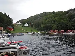
Hille[1] is an island in Lindesnes Municipality in Agder county, Norway.[2] The 4.2-square-kilometre (1.6 sq mi) island lies in the North Sea, about 5 kilometres (3.1 mi) southwest of the town of Mandal. The highest point on the island is the 96-metre (315 ft) tall mountain Garpeheia. The island is only accessible by boat, and it has one road which connects the two harbors on the north and east sides of the island. The island has a small permanent population, but it also has many holiday cottages all over the north and east sides of the island.
See also
References
- ↑ "Informasjon om stadnamn". Norgeskart (in Norwegian). Kartverket. Retrieved 15 June 2026.
- ↑ "Hille, Lindesnes" (in Norwegian). yr.no. Retrieved 15 June 2026.
Categories: