Grimstadfjorden
| Grimstadfjorden | |
|---|---|
| Grimstadfjord (unofficial)[1] | |
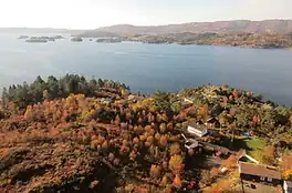 View of the fjord | |
Interactive map of Grimstadfjorden | |
| Location | Vestland county, Norway |
| Coordinates | 60°19′32″N 5°13′00″E / 60.32555°N 5.21679°E |
| Type | Fjord |
| Nordåsvannet | |
| Raunefjorden | |
| Basin countries | Norway |
| Max. length | 4 kilometres (2.5 mi) |
Grimstadfjorden[1] is a small fjord in Bergen Municipality in Vestland county, Norway. It is located about 8 kilometres (5.0 mi) southwest of the centre of the city of Bergen. The 4-kilometre (2.5 mi) long fjord lies on the western side of the Bergen Peninsula, and it divides the Laksevåg and Ytrebygda boroughs of the city of Bergen.[2]
Grimstadfjorden lies just north of Bergen Airport, Flesland and the Norwegian naval base Haakonsvern lies on the northern shore of the fjord. The lake Nordåsvannet flows to the west into this fjord and then this fjord flows west into the large Raunefjorden. The island of Bjorøyna lies at the western mouth of Grimstadfjorden.[3]
History

The German battleship Bismarck was moored here on 21 May 1941.[4][5]
References
- 1 2 "Informasjon om stadnamn". Norgeskart (in Norwegian). Kartverket. Retrieved 2025-12-31.
- ↑ Thorsnæs, Geir, ed. (2024-11-26). "Grimstadfjorden". Store norske leksikon (in Norwegian). Foreningen Store norske leksikon. Retrieved 2025-12-31.
- ↑ Hartvedt, Gunnar Hagen; Skreien, Norvall (2009). "Grimstafjorden". Bergen Byleksikon (in Norwegian). Oslo: Kunnskapsforlaget. p. 218. ISBN 9788257317614.
- ↑ Baron von Mullenheim-Rechberg, Burkhard (1980). Battleship Bismarck, A Survivor's Story. Annapolis: United States Naval Institute Press. p. 85. ISBN 978-0-87021-096-9.
- ↑ "Spionbilder på nett". Dagbladet (in Norwegian). 2004-01-18.
Categories: