Grange Lower
Grange Lower
An Ghráinseach Íochtarach | |
|---|---|
Townland | |
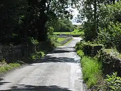 Johnville Bridge, in Grange Lower townland, spans the Powerstown River | |
  Grange Lower Location in Ireland | |
| Coordinates: 52°37′09″N 7°0′42″W / 52.61917°N 7.01167°W | |
| Country | Ireland |
| Province | Leinster |
| County | County Kilkenny |
| Civil parish | Grangesilvia |
| Area | |
• Total | 7.94 km2 (3.07 sq mi) |
| Time zone | UTC+0 (WET) |
| • Summer (DST) | UTC-1 (IST (WEST)) |
| Irish grid reference | S669523 |
Grange Lower (Irish: An Ghráinseach Íochtarach)[2] is a townland in the civil parish of Grangesilvia and the historical barony of Gowran in County Kilkenny, Ireland.[1] It is near the village of Goresbridge. Jeanville, historically known as Johnville, was a former estate in the area. The townland of Grange Lower, which has an area of approximately 7.94 square kilometres (3.07 sq mi),[1] had a population of 213 people as of the 2011 census.[3]
History

Evidence of ancient settlement in the townland of Grange Lower includes a cist grave which was discovered on a farm in Jeanville in 1960.[4][5] Other sites, recorded in the Record of Monuments and Places, include a number of barrow, tower house (castle) and enclosure sites.[6]
Johnville House, built in the area in 18th century, was occupied by the Davis family at the turn of the 19th century.[7] The area near the house became known as Johnville, and gradually Jeanville, owing to a concentration of Huguenots in the area. Johnville Bridge, named as such on Ordnance Survey maps, spans the Powerstown River nearby.[8]
See also
References
- 1 2 3 "Grange Lower Townland, Co. Kilkenny". townlands.ie. Retrieved 19 June 2026.
- ↑ "An Ghráinseach Íochtarach / Grange Lower". logainm.ie. Placenames Database of Ireland. Retrieved 19 June 2026.
- ↑ "CD158 - Kilkenny Population by Private Households, Occupied and Vacancy Rate". data.gov.ie. Central Statistics Office. Retrieved 19 June 2026.
Population [..] Townlands [..] Grange Lower, Goresbridge, Co. Kilkenny: 213
- ↑ Prendergast, Ellen (1962). "Prehistoric Grave Near Gowran" (PDF). Old Kilkenny Review (14). Kilkenny Archaeological Society: 18.
In the spring of 1960 a prehistoric grave was discovered by Mr. Thomas Mahony on his farm at Jeanville near Gowran. The exact location of the grave is in the townland of Grange Lower
- ↑ "NMS mapping data - KK025-009----" – via heritagedata.maps.arcgis.com.
KK025-009---- : Cist : Grange Lower [..] A short cist [..] discovered during ploughing in the spring of 1960 [..] Described by Prendergast (1962, 18-21)
- ↑ Record of Monuments and Places - County Kilkenny (PDF), National Monuments and Historic Properties Service, 1996 – via archaeology.ie
- ↑ "HSESIJ - Edward Law - Kilkenny History - Miscellaneous Houses". homepage.eircom.net. Archived from the original on 11 February 2009.
- ↑ 6 Inch OS Map - First Edition - County Kilkenny - Sheet 29 (Map). 6". Ireland: Ordnance Survey (Ireland). 1842.