Heilbronn-Frankenbach
| coat of arms | Location |
|---|---|
 | 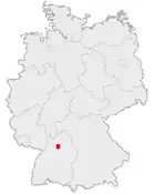 |
| Main facts | |
| Bundesland: | Baden-Württemberg |
| city: | Heilbronn |
| Coordinates: | 49° 10' N, 09° 10' E |
| population: | ca. 5597 (2006) |
| Address of the official-administration: | Speyerer Straße 13 74078 Heilbronn |
| position | |
 | |

Frankenbach (German: [ˈfʁaŋkn̩bax] ⓘ) has been a borough of Heilbronn, Baden-Wüttemberg, since 1974. It is situated in the North-West, about 4.5 kilometres as crow flies from the centre.[1]
Frankenbach was first mentioned in 766 and belonged to Heilbronn from the early 15th century. The St. Albans church was mentioned first in 1472 and became a Protestant church along with the city of Heilbronn during the Protestant Reformation. The catholic St. Johannes church was built in 1972.[2]
References
- ↑ "Heilbronn - Detailseite - LEO-BW". www.leo-bw.de. Retrieved 2026-06-10.
- ↑ "Stadtteil Frankenbach - mein-heilbronn.org". www.mein-heilbronn.org. Retrieved 2026-06-10.
Category: