List of earthquakes in Iran

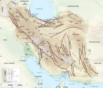
Iran is one of the most seismically active countries in the world, being crossed by several major faults that cover at least 90% of the country.[1] As a result, earthquakes in Iran occur often and are destructive.
Geology and history
The Iranian plateau is subject to most types of tectonic activity, including active folding, faulting and volcanic eruptions. It is well known for its long history of disastrous earthquake activity. Not only have these earthquakes killed thousands, but they have also led to waste of valuable natural resources.[2] Since 1900, at least 126,000 fatalities have resulted from earthquakes in Iran.[2] In addition, the Iranian plate is bordered by the Indian plate (to the southeast), the Eurasian plate (to the north), and the Arabian plate (to the south and west), which is where the Zagros fold and thrust belt (an ancient subduction zone) lies.
Present danger
On Sunday, December 28, 2025, Iranian news media reported the occurrence of an earthquake in the northeastern province of Tehran.[3] They also published a report indicating that in the event of a major earthquake in Greater Tehran, 73% of all highways and roads would be damaged beyond repair, making all rescue operations impossible.[3] The reaction of Mehdi Chamran, Chairman of the Tehran City Council: “We hope and pray to God that an earthquake does not occur; otherwise, we will face a major problem.”[3] Parviz Sorouri, Vice Chairman of the Tehran City Council, said: “Tehran is located on active fault lines, and this is undeniable. In the event of a severe earthquake in Tehran, we may face an unprecedented or nearly unprecedented catastrophe in world history.”[3] Recently, Ali Beitollahi, Head of the Engineering Seismology and Seismic Risk Department at the Road, Housing, and Urban Development Research Center, said: “The phenomenon of land subsidence is increasingly developing across Iran and threatens 40 percent of the country’s population.”[3]
Earthquakes
| Date | Province | Mag. | MMI | Deaths | Injuries | Total damage / notes | Citations |
|---|---|---|---|---|---|---|---|
| 2024-06-18 | Razavi Khorasan | 4.9 mb | 4 | 120 | Severe damage | [4][5] | |
| 2023-03-24 | West Azerbaijan | 5.6 Mw | VIII | 165 | Severe damage | [6] | |
| 2023-01-28 | West Azerbaijan | 5.9 Mw | VII | 3 | 1,750 | Widespread damage | [7] |
| 2023-01-18 | West Azerbaijan | 5.7 Mw | VI | 252 | Severe damage | [8] | |
| 2022-10-05 | West Azerbaijan | 5.6 Mw | VII | 1,127 | Severe damage | [9] | |
| 2022-07-23 | Hormozgan | 5.6 Mw | VII | 1 | Minor damage | [10][11] | |
| 2022-07-03 | Gilan | 4.1 mb | 1 | Minor damage | [12][13][14] | ||
| 2022-07-01 | Hormozgan | 6.0 Mw | VII | 7 | 111 | Severe damage / doublet | [15][16] |
| 2022-06-25 | Hormozgan | 5.6 Mw | VII | 1 | 37 | [17] | |
| 2022-04-23 | Fars | 4.4 mb | VI | 1 | Minor damage | [18][19] | |
| 2022-03-20 | Fars | 4.7 mb | VII | 2 | Minor damage | [20][21] | |
| 2022-03-16 | Hormozgan | 5.9 Mw | VII | 2 | Minor damage | [22][23] | |
| 2022-01-23 | East Azerbaijan | 4.0 mb | VII | 1 | [24] | ||
| 2021-11-14 | Hormozgan | 6.4 Mw | IX | 2 | 98 | Doublet | [25][26] |
| 2020-05-07 | Tehran | 4.6 mb | V | 2 | 38 | [27][28] | |
| 2020-02-23 | West Azerbaijan | 5.8 Mw | VII | 10 | 125 | [29] | |
| 2019-11-07 | East Azerbaijan | 5.9 Mw | VII | 7 | 584 | [30] | |
| 2019-07-08 | Khuzestan | 5.6 Mw | VII | 1 | 100 | [31] | |
| 2018-11-25 | Kermanshah | 6.3 Mw | VI | 1 | 761 | Aftershock | [32] |
| 2018-08-25 | Kermanshah | 6.0 Mw | VII | 3 | 243 | Aftershock | [33] |
| 2017-12-20 | Tehran | 5.2 Mw | VI | 2 | 97 | 4.0 Mwaftershock: 1 dead, 75 injured | |
| 2017-11-12 | Kermanshah | 7.3 Mw | IX | 630 | 8,435 | ||
| 2017-05-13 | North Khorasan | 5.6 Mw | VII | 3 | 370 | ||
| 2017-04-05 | Khorasan-e Razavi | 6.1 Mw | VII | 2 | 34 | ||
| 2017-01-06 | Fars | 5.0 Mw | VI | 4 | 5 | ||
| 2014-08-18 | Ilam | 6.2 Mw | VIII | 60–330 | |||
| 2013-11-28 | Bushehr | 5.6 Mw | VII | 7 | 45 | ||
| 2013-04-13 | Sistan and Baluchestan | 7.7 Mw | VIII | 35 | 117 | ||
| 2013-04-09 | Bushehr | 6.3 Mw | VIII | 37 | 850 | ||
| 2012-08-11 | East Azerbaijan | 6.4 Mw | VIII | 306 | 3,037 | Doublet | |
| 2012-08-11 | East Azerbaijan | 6.3 Mw | Doublet | ||||
| 2011-06-15 | Kerman | 5.3 | 2 | ||||
| 2010-12-20 | Kerman | 6.5 Mw | IX | 11 | 100 | ||
| 2010-08-27 | Semnan | 5.8 Mw | VII | 4 | 40 | 800 displaced | |
| 2010-07-30 | Razavi Khorasan | 5.5 Mw | VI | 274 | Severe damage | ||
| 2008-09-10 | Qeshm | 5.9 Mw | VIII | 7 | 45 | ||
| 2006-03-31 | Lorestan | 6.1 Mw | VIII | 63–70+ | 1,246–1,418 | ||
| 2005-11-27 | Qeshm | 5.8 Mw | VII | 13 | 100 | ||
| 2005-02-22 | Kerman | 6.4 Mw | VIII | 612 | 1,411 | ||
| 2004-05-28 | Māzandarān | 6.3 Mw | VIII | 35 | 278–400 | $15.4 million | |
| 2003-12-26 | Kerman | 6.6 Mw | IX | 34,000 | 200,000 | 45,000–75,600 displaced | [34] |
| 2002-06-22 | Qazvin | 6.3 Mw | VIII | 261 | 1,500 | ||
| 1999-11-19 | Semnan | 5.6 Mw | -- | -- | unknown | unknown | [35] |
| 1999-03-04 | Kerman | 6.6 Mw | VII | 1 | 517 houses damaged | [36] | |
| 1998-03-14 | Kerman | 6.6 Mw | VIII | 5 | 50 | [37] | |
| 1997-05-10 | South Khorasan | 7.3 Mw | X | 1,567 | 2,300 | ||
| 1997-02-28 | Ardabil | 6.1 Mw | VIII | 1,100 | 2,600 | ||
| 1997-02-04 | North Khorasan | 6.5 Mw | VIII | 100 | 1,948 | ||
| 1990-06-20 | Gilan | 7.4 Mw | X | 35,000–50,000 | 60,000–105,000 | ||
| 1981-07-28 | Kerman | 7.1 Ms | IX | 1,500 | 1,000 | ||
| 1981-06-11 | Kerman | 6.6 Mw | VIII+ | 1,400–3,000 | many | ||
| 1979-11-14 | South Khorasan | 6.8 Mw | VIII | 297–440 | |||
| 1978-09-16 | South Khorasan | 7.4 Mw | IX | 15,000–25,000 | |||
| 1977-12-19 | Kerman | 5.9 Mw | VII | 584–665 | |||
| 1977-04-06 | Chaharmahal and Bakhtiari | 6.0 Mw | VIII | 348–366 | |||
| 1977-03-21 | Hormozgan | 7.0 Ms | VIII | 152–167 | |||
| 1972-04-10 | Fars | 6.7 Mw | IX | 5,374 | 1,710 | ||
| 1970-07-30 | Khorasan | 6.4 | 175 | 450 | [38][39] | ||
| 1968-08-31 | South Khorasan | 7.4 Mw | X | 15,000 | |||
| 1968-09-01 | South Khorasan | 6.4 Mw | 900 | ||||
| 1965-02-10 | East Azerbaijan | 5.1 | 20 | ||||
| 1962-09-01 | Qazvin | 7.1 ML | IX | 12,225 | 2,776 | ||
| 1960-04-24 | Fars | 6.0 Muk | 420 | [40] | |||
| 1958-08-16 | Hamadan | 6.7 Muk | 132 | [40] | |||
| 1957-12-13 | Kermanshah | 7.1 | 1,130 | ||||
| 1957-07-02 | Māzandarān | 7.1 | 1,200 | ||||
| 1953-02-12 | Semnan | 6.6 Mw | VIII | 800–973 | 140 | ||
| 1947-08-05 | South Khorasan | 7.3 | 500 | ||||
| 1932-05-20 | Māzandarān | 5.4 Muk | VIII | 1,070 | [40] | ||
| 1930-05-07 | West Azerbaijan | 7.1 Mw | IX | 1,360–3,000 | |||
| 1929-05-01 | Khorasan-e Razavi | 7.2 Mw | IX | 3,257–3,800 | 1,121 | ||
| 1923-05-25 | Khorasan-e Razavi | 5.9 Mw | VII+ | 2,200 | More than 7 villages destroyed | [41] | |
| 1909-01-23 | Lorestan | 7.3 ML | IX | 6,000–8,000 | |||
| 1895-01-17 | Khorasan-e Razavi | 6.8 Ms | VIII | 1,000–11,000 | |||
| 1893-11-17 | Khorasan-e Razavi | 6.6 Ms | X | 18,000 | [42] | ||
| 1872-01-06 | North Khorasan | 5.6 | VII | 4,000 | [43] | ||
| 1871-12-23 | North Khorasan | 6.3 | VII | 2,000 | [43] | ||
| 1864-01-17 | Kerman | VIII | Many | [40] | |||
| 1853-05-05 | Fars | IX | 9,000–13,000 | [40] | |||
| 1778-12-15 | Kashan | 6.2 Ms | >8,000 | [42] | |||
| 1755-06-07 | Isfahan | 40,000 | |||||
| 1727-11-18 | East Azerbaijan | VIII | 77,000 | ||||
| 1721-04-26 | East Azerbaijan | 7.7 Ms | VIII–X | 8,000–250,000 | |||
| 1679-06-04 | Yerevan, Armenia | 6.4 Ms | IX–X | 7,600 | Under Iranian rule at the time | ||
| 1667-11-25 | Shamakhi, Azerbaijan | 6.9 Ms | X | 80,000 | Under Iranian rule at the time | ||
| 1641-02-05 | Tabriz, East Azerbaijan | 6.8 Ms | IX | 30,000 | Tabriz completely destroyed | ||
| 1101-??-?? | Khorasan-e Razavi | 6.5 Muk | X | 60,000 | [43] | ||
| 1042-08-21 | East Azerbaijan | 7.6 | 40,000 | ||||
| 1008-04-11 | Bushehr | 6.5 Ms | 16,000 | [43] | |||
| 978-06-17 | Bushehr | 5.3 Ms | 2,000 | [43] | |||
| 893-03-23 | Ardabil | 150,000 | See also 893 Dvin earthquake | ||||
| 856-12-22 | Semnan | 7.9 Ms | X | 200,000 | |||
| 850-07-15 | Tehran | 45,000 | [43] | ||||
| 743-??-?? | Semnan | 7.2 Ms | IX | [43] | |||
| 662-04-26 | Semnan | 40,000 | [43] | ||||
| 400? BCE | Tehran | 7.6 | [43] | ||||
| Note: Mw = moment magnitude scale, Ms = surface-wave magnitude, and Muk = unknown. The inclusion criteria for adding events are based on WikiProject Earthquakes' notability guideline that was developed for stand alone articles. The principles described also apply to lists. In summary, only damaging, injurious, or deadly events should be recorded. | |||||||
See also
References
- ↑ "Preliminary Earthquake Reconnaissance Report on the June 22, 2002 Changureh (Avaj), Iran Earthquake". International Institute of Earthquake Engineering and Seismology. 2002-07-19. Archived from the original on March 25, 2010. Retrieved December 30, 2008.
- 1 2 Manuel Berberian. "100 years; 126,000 deaths". The Iranian.
- 1 2 3 4 5 "پژوهش تازه: ۷۳ درصد راههای استان تهران در برابر زلزله آسیبپذیر هستند". www.iranintl.com (in Persian). 2025-12-28. Retrieved 2025-12-30.
- ↑ "M 4.9 – 6 km SE of Kāshmar, Iran". United States Geological Survey. 18 June 2024.
- ↑ "۹۰۰ واحد مسکونی در زلزله کاشمر آسیب دیده است" [900 residential units damaged in Kashmir earthquake city] (in Persian). Islamic Republic News Agency. 22 June 2024.
- ↑ "M 5.6 – 13 km SW of Khowy, Iran". United States Geological Survey. 24 March 2023.
- ↑ "M 5.9 – 14 km SSW of Khowy, Iran". United States Geological Survey. 28 January 2023.
- ↑ "M 5.7 – 12 km S of Khowy, Iran". United States Geological Survey. 18 January 2023.
- ↑ "M 5.6 – 8 km SE of Khowy, Iran". United States Geological Survey. 5 October 2022.
- ↑ "M 5.6 – 69 km NE of Bandar-e Lengeh, Iran". United States Geological Survey. 23 July 2022.
- ↑ "مصدوم زلزله هرمزگان". ghatreh (in Persian). 24 July 2022.
- ↑ "M 4.1 – 37 km N of Astaneh-ye Ashrafiyeh". United States Geological Survey. 3 July 2022.
- ↑ "M 4.3 – NEAR THE COAST OF NORTHERN IRAN – 2022-07-03 14:05:33 UTC". European-Mediterranean Seismological Centre.
- ↑ زلزله گیلان یک مصدوم بر جای گذاشت. Young Journalists Club (in Persian). 3 July 2022. Archived from the original on 31 July 2024. Retrieved 4 July 2022.
- ↑ "M 6.0 – 52 km NE of Bandar-e Lengeh, Iran". United States Geological Survey. 1 July 2022.
- ↑ "M 6.0 – 57 km NE of Bandar-e Lengeh, Iran". United States Geological Survey. 1 July 2022.
- ↑ "M 5.6 – 31 km NE of Kīsh, Iran". United States Geological Survey. 25 June 2022.
- ↑ "M 4.4 – southern Iran". United States Geological Survey. 23 April 2022.
- ↑ "وقوع زلزله در منطقه خان زنیان، تاکنون یک مصدوم داشت". sums.ac.ir (in Persian). Archived from the original on 2022-06-02. Retrieved 2022-05-12.
- ↑ "M 4.7 – 90 km SE of Dārāb, Iran". United States Geological Survey. 19 March 2022.
- ↑ "زلزله داراب فارس ۲ مصدوم داشت" [Darab Fars earthquake had 2 casualties] (in Persian). Islamic Republic News Agency.
- ↑ "M 5.9 – 59 km NNW of Bandar e-Lengeh, Iran". United States Geological Survey. 16 March 2022.
- ↑ "See | The latest details of the Hormozgan earthquake 2 outpatient injured were treated". hamshahrionline.com (in Persian). 17 March 2022. Retrieved 17 March 2022.
{{cite news}}: CS1 maint: deprecated archival service (link) - ↑ "M 4.0 – Northwestern Iran". United States Geological Survey. 23 January 2022.
- ↑ "Dubai and Abu Dhabi feel tremors from 6.2 magnitude quake in Iran". The National. 14 November 2021. Retrieved 2021-11-14.
- ↑ "Overall Orange Earthquake alert in Islamic Republic of Iran on 14 Nov 2021 12:08 UTC". gdacs.org. Retrieved 2021-11-14.
- ↑ "M 4.6 – 3 km NNW of Damavand, Iran". United States Geological Survey. 7 May 2020.
- ↑ "Moderate Iran quake kills two, draws many into Tehran streets". Reuters. 8 May 2020. Archived from the original on 9 May 2020. Retrieved 11 May 2020.
- ↑ "M 5.8 - 41 km NW of Salmas, Iran". United States Geological Survey. 23 February 2020.
- ↑ APA.az (2019-11-09). "Number of wounded reaches 529 in quake in Eastern Azerbaijan province of Iran". apa.az (in Azerbaijani). Retrieved 2019-11-09.
- ↑ "M 5.6 – 31 km SE of Masjed Soleyman, Iran". United States Geological Survey. 8 July 2019.
- ↑ "M 6.3 – 15 km SW of Sarpol-e Zahab, Iran". United States Geological Survey. 25 November 2018.
- ↑ "M 6.0 – 32 km SW of Javanrud, Iran". United States Geological Survey. 25 August 2018.
- ↑ "After 17 Years Iran Finally Announces 34,000 Died in Bam Earthquake". Iran International. December 26, 2020. Archived from the original on August 26, 2021. Retrieved August 26, 2021.
- ↑ "Earthquake hits Iran". BBC News. 19 November 1999. Retrieved 25 March 2026.
- ↑ "M 6.6 – 110 km SSE of K?h Sef?d, Iran". United States Geological Survey. Retrieved 2022-03-11.
- ↑ Berberian 2014, p. 617
- ↑ "Quake Levels Iranian Villages", Pittsburgh Post-Gazette, July 31, 1970, p1
- ↑ "M 6.4 – 52 km NE of Kal?leh, Iran". United States Geological Survey. Retrieved 8 October 2022.
- 1 2 3 4 5 NGDC (1972), Significant Earthquake Database (Data Set), National Geophysical Data Center, NOAA, doi:10.7289/V5TD9V7K, archived from the original on September 29, 2006
- ↑ Berberian 2014, p. 593
- 1 2 Ambraseys N.N.; Melville C.P. (2005). A History of Persian Earthquakes. Cambridge University Press. pp. 53–54, 160. ISBN 9780521021876.
- 1 2 3 4 5 6 7 8 9 "Search results Country=Iran, Year <2025". NGDC.
Sources
- Berberian, M. (2014), Earthquakes and Coseismic Surface Faulting on the Iranian Plateau, Developments in Earth Surface Processes (1st ed.), Elsevier, ISBN 978-0444632920
External links
- Latest earthquakes in Iran and adjacent areas Archived 2022-10-20 at the Wayback Machine – Iranian Seismological Center

List of earthquakes in Asia | |
|---|---|
| Sovereign states |
|
| States with limited recognition |
|
| Dependencies and other territories |
|
