Cushendun Formation
| Cushendun Formation | |
|---|---|
| Stratigraphic range: | |
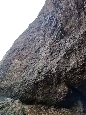 Outcrop at Cushendun Bay | |
| Type | Geological formation |
| Unit of | Old Red Sandstone |
| Underlies | Ballyagan Formation and Cushendall Formation |
| Overlies | Dalradian Supergroup (unconformity) |
| Thickness | up to 600 metres (1,970 ft) |
| Lithology | |
| Primary | Breccia, schist, conglomerate |
| Other | Quartzite |
| Location | |
| Region | County Antrim |
| Country | Northern Ireland |
| Extent | Cushendun Bay and Cushendun Caves |
| Type section | |
| Named for | Cushendun |
| Named by | Simon |
| Year defined | 1984b[1] |
The Cushendun Formation, also known as the Cushendun Conglomerate, is a geologic formation of Early Devonian age in Northern Ireland where it outcrops at Cushendun, County Antrim.[2]
History
Surveys of Cushendun Bay were undertaken in 1886 and it was concluded that the rocks were metamorphic in origin.[3] The first geological maps of the area were produced by Bailey & McCallien (1934),[4] and Wilson (1953) was the first to conclude the rocks were Early Devonian in age and he placed them into the Old Red Sandstone as a new, unnamed member.[5]
Simon (1984b) defined the Cushendun Formation as a separate geological formation then known as the "Cushendun Conglomerate".[1]
Geology and location

The formation is formed of thin breccia clasts overlain by conglomerate and quartzite.[2] The age of the formation can not be dated any more precisely than the Early Devonian due to the lack of fossils preserved,[6] and it was part of the Cross Slieve Group in the Lower Old Red Sandstone.[1] It overlies the Precambrian age Dalradian Supergroup at its base through an unconformity, and it underlies the Early Devonian age Ballyagan Formation.[1] The formation is also up to 600 metres (2,000 ft) thick in places and has clasts of up to 20 centimetres (7.9 in) long.[2][6]
The Cushendun Formation outcrops only at Cushendun Bay and the nearby Cushendun Caves (which formed the current cave system around 100,000 years ago)[7] on the northeastern section of Cross Slieve;[1] the southeastern section is dominated by the Cushendall Formation.[8]

Paleogeography
It is believed that the Cushendun Formation represented a desert environment where the larger rocks were deposited by a braided river stream.[6][7]
References
- 1 2 3 4 5 Simon, J B. (1984b). Provenance and depositional history of the Lower Old Red Sandstone of northeast Antrim. Irish Journal of Earth Sciences 6, 213-228.
- 1 2 3 "Cushendun Formation". British Geological Survey. Retrieved 25 January 2026.
- ↑ Cushendall, Sheet 14 Geological Survey of Ireland, 1886
- ↑ Bailey, E.B. and McCallien, W.J. (1934): The metamorphic rocks of North-east Antrim. Transactions of the Royal Society of Edinburgh: Earth Sciences, vol. 58, pp.163-177
- ↑ Wilson, H. E. (1953): The petrography of the Old Red Sandstone rocks of the north of Ireland. Proceedings of the Royal Irish Academy, vol. 55, pp.283-320
- 1 2 3 "Devonian - Cross Slieve Group; Cushendun to Port Obe". Earth Science Conservation Review. Retrieved 25 January 2026.
- 1 2 "Conglomerate, County Antrim". The Geological Society. Retrieved 25 January 2026.
- ↑ "Cushendall Formation". British Geological Survey. Retrieved 25 January 2026.