Crozier (crater)
 LRO image | |
| Coordinates | 13°30′S 50°48′E / 13.5°S 50.8°E |
|---|---|
| Diameter | 22.51 km (13.99 mi)[1] |
| Depth | 1.3 km (0.81 mi)[2] |
| Colongitude | 310° at sunrise |
| Eponym | Francis R. M. Crozier |
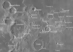

Crozier is a lunar impact crater that is located on the southwest edge of Mare Fecunditatis, a lunar mare in the eastern part of the Moon's near side. It lies to the east-northeast of the prominent crater Colombo,[3] and southeast of the small crater Bellot.[4]
The narrow rim of this crater forms a distorted enclosure that has outward bulges along the northwest, southwest, and southeastern sides.[4] The interior has been resurfaced and nearly filled by basaltic lava, producing a level floor with a low albedo that matches the dark hue of the nearby lunar mare. Nearly adjacent to the outer rim are the similar flooded craters Crozier D to the east and Crozier M to the southeast.[5]: 79–80 A diffuse lunar swirl occurs to the southeast of Crozier.[6]
The crater is named after Irish Royal Navy officer and polar explorer Francis Crozier (1796-1848). His name was introduced in the lunar nomenclature of William R. Birt and John Lee during the 19th century.[7] Its designation was officially adopted by the International Astronomical Union in 1935.[1]
Satellite craters
By convention these features are identified on lunar maps by placing the letter on the side of the crater midpoint that is closest to Crozier.[8]
| Crozier[5]: 296 | Coordinates | Diameter, km |
|---|---|---|
| B | 12°33′S 52°23′E / 12.55°S 52.39°E | 8.9 |
| D | 13°28′S 51°35′E / 13.46°S 51.59°E | 19.4 |
| E | 12°40′S 51°57′E / 12.67°S 51.95°E | 6.0 |
| F | 12°47′S 51°00′E / 12.79°S 51.00°E | 4.6 |
| G | 12°01′S 49°59′E / 12.02°S 49.99°E | 4.1 |
| H | 14°01′S 49°23′E / 14.01°S 49.38°E | 10.5 |
| L | 10°00′S 51°30′E / 10.00°S 51.50°E | 8.4 |
| M | 8°50′S 51°22′E / 8.84°S 51.36°E | 5.9 |


References
- 1 2 "Crozier". Gazetteer of Planetary Nomenclature. USGS Astrogeology Research Program. Retrieved 2026-07-16.
- ↑ Pike, R. J. (September 1976). "Crater Dimensions from Apollo Data and Supplemental Sources". The Moon. 15 (3–4): 463–477. Bibcode:1976Moon...15..463P. doi:10.1007/BF00562253.
- ↑ Moore, Patrick (2001). On the Moon. Sterling Publishing Co. p. 220. ISBN 978-0-304-35469-6.
- 1 2 The region overlaps two charts:
- 1 2 Bussey, B.; Spudis, P. (2004). The Clementine Atlas of the Moon. New York: Cambridge University Press. ISBN 978-0-521-81528-4.
- ↑ Denevi, B. W.; et al. (July 2016). "The Distribution and Extent of Lunar Swirls". Icarus. 273: 53–67. Bibcode:2016Icar..273...53D. doi:10.1016/j.icarus.2016.01.017.
- ↑ Whitaker, Ewen A. (1999). Mapping and Naming the Moon. Cambridge University Press. p. 136, 221. ISBN 978-0-521-62248-6.
- ↑ Grego, P. (2015). "Satellite Crater". In Hargitai, H.; Kereszturi, Á. (eds.). Encyclopedia of Planetary Landforms. New York, NY: Springer. doi:10.1007/978-1-4614-3134-3_328.
- ↑ Dembowski, William M. (October 2006). "Enigmatic lunar craters". Journal of the Association of Lunar & Planetary Observers, The Strolling Astronomer (ISSN 0039-2502). 48 (4): 27–31. Bibcode:2006JALPO..48d..27D.
Sources
- Price, Fred W. (1988). The Moon Observer's Handbook. Cambridge University Press. ISBN 978-0-521-33500-3.
- Rükl, Antonín (1990). Atlas of the Moon. Kalmbach Books. ISBN 978-0-913135-17-4.
- Wlasuk, Peter T. (2000). Observing the Moon. Springer. ISBN 978-1-85233-193-1.
| Physical properties |  | |
|---|---|---|
| Orbit | ||
| Surface and features | ||
| Science | ||
| Exploration | ||
| Time-telling and navigation | ||
| Phases and names | ||
| Daily phenomena | ||
| Related |
| |
