Athner
Athner | |
|---|---|
  Athner Location within Madhya Pradesh  Athner Location within India | |
| Coordinates: 21°37′N 77°55′E / 21.62°N 77.92°E | |
| Country |  India |
| State |  Madhya Pradesh |
| District | Betul |
| Region | Narmadapur Division |
| Ward | 15 wards |
| Government | |
| • Type | Nagar panchayat |
| Population (2024) | |
• Total | 25,915 |
| • Density | 3,192/km2 (8,270/sq mi) |
| Languages | |
| • Official | Hindi |
| Time zone | UTC+5:30 (IST) |
| PIN | 460110 |
| Vehicle registration | MP 48 |
| Literacy rate (2011) | 85.64% |
Athner is a nagar parishad located in Betul District of Madhya Pradesh, India.[1]
Boundaries
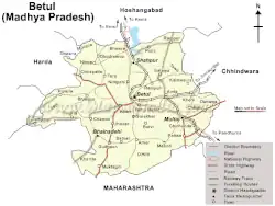
Betul (35 km), Multai (48 km), Bhainsdehi (32 km), and Amla (57 km), are the closest cities to Athner.
Khapa (6 km), Gunkhed (3 km), Dhamori (3 km), Gujarmal (4 km), and Yenkheda (5 km) are the nearby villages to athner.
Athner is surrounded by Prabhat Pattan Tehsil to the east, Bhinsdhi Tehsil to the west, Betul Tehsil the to the north, and Amravati Tehsil to the south.
Demographics
Athner had a population of 25,915, of whom 12,991 were male and 12,924 were female, per the 2011 census.[2]
Transport
Roadways
Athner is located on the Multai – Benshdhi state Highway. It is well connected by road, being connected to Betul, Multai, Amla, and Bhainsdehi. A daily bus service is available.
Railways
The nearest railway station is Betul railway station, which is 35 km from Athner.
Airways
The nearest airport is Raja Bhoj Airport Bhopal, which is 214 km from Harda, and Devi Ahilya Bai Holkar Airport Indore, which is 306 km from Athner.
Climate
| Climate data for Athner, Madhya Pradesh (1981–2010, extremes 1948–2012) | |||||||||||||
|---|---|---|---|---|---|---|---|---|---|---|---|---|---|
| Month | Jan | Feb | Mar | Apr | May | Jun | Jul | Aug | Sep | Oct | Nov | Dec | Year |
| Record high °C (°F) | 34.9 (94.8) |
37.8 (100.0) |
42.3 (108.1) |
43.7 (110.7) |
48.0 (118.4) |
44.5 (112.1) |
38.6 (101.5) |
33.6 (92.5) |
35.5 (95.9) |
36.8 (98.2) |
35.0 (95.0) |
32.7 (90.9) |
48.0 (118.4) |
| Mean daily maximum °C (°F) | 27.4 (81.3) |
30.1 (86.2) |
34.6 (94.3) |
38.7 (101.7) |
40.3 (104.5) |
35.7 (96.3) |
29.2 (84.6) |
27.6 (81.7) |
29.8 (85.6) |
31.1 (88.0) |
29.1 (84.4) |
27.8 (82.0) |
31.8 (89.2) |
| Daily mean °C (°F) | 18.9 (66.0) |
21.0 (69.8) |
25.3 (77.5) |
29.7 (85.5) |
32.5 (90.5) |
30.0 (86.0) |
25.8 (78.4) |
24.7 (76.5) |
25.4 (77.7) |
24.2 (75.6) |
21.2 (70.2) |
19.0 (66.2) |
24.8 (76.7) |
| Mean daily minimum °C (°F) | 10.5 (50.9) |
11.9 (53.4) |
16.1 (61.0) |
20.6 (69.1) |
24.7 (76.5) |
24.4 (75.9) |
22.5 (72.5) |
21.8 (71.2) |
21.1 (70.0) |
17.3 (63.1) |
13.4 (56.1) |
10.2 (50.4) |
17.9 (64.2) |
| Record low °C (°F) | −0.2 (31.6) |
1.1 (34.0) |
2.3 (36.1) |
10.6 (51.1) |
16.6 (61.9) |
14.9 (58.8) |
14.5 (58.1) |
13.1 (55.6) |
10.5 (50.9) |
5.0 (41.0) |
2.6 (36.7) |
1.3 (34.3) |
−0.2 (31.6) |
| Average rainfall mm (inches) | 13.8 (0.54) |
14.2 (0.56) |
19.7 (0.78) |
6.9 (0.27) |
13.3 (0.52) |
144.5 (5.69) |
330.1 (13.00) |
371.7 (14.63) |
189.8 (7.47) |
57.8 (2.28) |
20.6 (0.81) |
8.6 (0.34) |
1,191 (46.89) |
| Average rainy days | 1.1 | 1.5 | 1.4 | 0.7 | 0.9 | 8.0 | 15.2 | 15.5 | 8.8 | 3.2 | 1.7 | 0.8 | 58.7 |
| Average relative humidity (%) (at 17:30 IST) | 44 | 34 | 25 | 20 | 24 | 53 | 77 | 84 | 74 | 60 | 52 | 47 | 50 |
| Source: India Meteorological Department[4][5] | |||||||||||||
Geography
Athner is located at 21°37′N 77°55′E / 21.62°N 77.92°E, within the Satpura Range in the southern part of the district. It has an average elevation of 741 metres (2,431 ft).[6]
Economy
Its people depend on farming and business. Wheat, maize and soybeans are the main crops.
Administration
Athner is a tehsil headquarter in Betul District, containing 98 villages.
It is divided into 15 wards for which elections are held every five years.[7]
It is divided into eight subdivisions:
- Vikas Nagar
- Bhagwati Nagar
- Gunwant Nagar
- Gayatri Nagar
- Azad Nagar
- Shanti Nagar
- Patal Maholla
- Hanuman Maholla
References
- ↑ "Municipalities | District Betul, Government of Madhaya Pradesh | India".
- ↑ "Athner Nagar Panchayat City Population Census 2011-2024 | Madhya Pradesh". www.census2011.co.in.
- ↑ Baseline Survey of Bhopal District, Madhya Pradesh Archived 3 September 2013 at the Wayback Machine Ministry of Minority Affairs, Government of India (2012)
- ↑ "Station: athner Climatological Table 1981–2010" (PDF). Climatological Normals 1981–2010. India Meteorological Department. January 2015. pp. 123–124. Archived from the original (PDF) on 5 February 2020. Retrieved 28 December 2020.
- ↑ "Extremes of Temperature & Rainfall for Indian Stations (Up to 2012)" (PDF). India Meteorological Department. December 2016. p. M115. Archived from the original (PDF) on 5 February 2020. Retrieved 28 December 2020.
- ↑ "Maps, Weather, and Airports for Atner, India".
- ↑ "Sub Division and Tehshil | District Betul, Government of Madhaya Pradesh | India".